
By Alyssa Stahr – Inside Towers Special Correspondent
 Inside Towers recently touched on Chad Tuttle and Dinesh Bhat’s B+T Group’s new technology, Site360, but we decided that it was so cool, we wanted to get an even closer look.
Tuttle, the company’s CEO, said during a phone interview, that the company started hearing all the buzz about drones and wanted to look into technology. Tulsa, OK-based B+T constantly looks for new ways to increase efficiency and provide new services for its clients, and that’s how Site360 got started.
“What drives us every day as we’re going down this road on Site360, or anything new we’re going to do, is you have to create a deliverable that’s useful,” Tuttle said. “It’s got to be printable and it’s got to be scalable, and a lot of surveyors say ‘I can scan your tower with Lidar.’ It’s a $100,000 piece of equipment, and it takes six hours. That’s not feasible in the tower world.”
Tuttle loves the idea of going to a site, scanning things and getting dimensions without having to walk around with a tape measure. Photogrammetry, while not a new concept, gets great photos and dimensions so that Site360 can create useful deliverables for clients via point cloud technology.
“So that’s what Jay (Perkins, director of research and development) and our development team have done that we think is really special is we’ve figured out the processes in the field to gather the information,” Tuttle said.
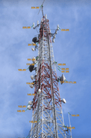
A lot of the onsite work is done from the ground.Clients want to send one person to the site to be more cost-effective. That was the first thing B+T tried to tackle—what information can they get from the ground? From the ground, you can’t get model numbers from antennas because you must climb to read tags or use a drone. However, from the ground, you can scan a compound and get exact dimensions, elevations, downtilts and more, and then deliver that information to the client in a more suitable way.
“We’re engineers, so we’re going out to sites to do a set of construction drawings. Traditionally, up to this point, we have always walked out there with a tape measure and a sketchpad, and we take all of our measurements, do a drawing of the compound and then bring that back to somebody in the office, and they do a CAD drawing,” Tuttle said. “Then, while we’re out there, we also take a bunch of pictures. Inevitably, you always miss a photo or forget a measurement, and the site is 300 miles away, so going back isn’t really an option.”
Previously, 200 photographs were taken of a compound and a tower, delivered to a client in a folder who then had to sift through the options to find the one they’re looking for. The beauty of Site360 is that the program can stitch all of those photos together. When you play it, it looks like a video. You can stop at any point, zoom in, pan around and see everything.. With high resolution cameras, you can zoom into the top of a 200-foot tower and see the feedline connecting to the back of the antenna. Now, the client can sit at his or her desk as if they are at the site and tour the it from any direction.
“We think that’s powerful,” Tuttle said. “At the same time while we’re doing all of those photographs, the technology is collecting millions of three dimensional data points. Basically, if you use the proper methods when you’re out there, the camera uses its focal length and knows how to capture these points and you feed them into a computer.”
B+T has written custom software that feeds those photos into a computer at a data center, which crunches the data for several hours. It creates what’s called a ‘point cloud,’ which are millions of dots that it captured. Then, you can take that point cloud and start manipulating data from it, including bringing it into AutoCAD and creating drawings.
Additionally, B+T has developed a new deliverable called ‘photo synth’ that includes elevations. The video spins around the entire tower as if you’re walking around it, showing the elevation of every antenna on the tower.
“The great thing about that is we didn’t type all those elevations in, which would lead to typing errors and mistakes. We read the software that extracts and calculates that information, and it’s really accurate—way more accurate than someone in a tower with a tape measure. And it’s automated,” Tuttle said. “We’ve reduced the mistakes, we’ve improved the accuracy, and now, if you’re someone out on a site and you’re looking at that on your phone or on your tablet, you can zoom in and look up at the antenna that you’re interested in, and it has an elevation right beside it. You know exactly what you’re looking at, as opposed to being out there with a drawing blowing around in the wind. You can have the greatest drawing in the world, and it’s still not as good as a photo.”
With so much changing on towers all the time, Tuttle finds Site360’s accuracy very exciting.
“The whole industry struggles with getting accurate information with what the inventory is on the tower. This is all about getting that accurate information, reducing trips to the site, improving the construction process, reducing change orders,” he said.
Tuttle stressed that the company isn’t “anti-drone,” as drones certainly have had a role in the process. But, they are still using climbers because they think there is a lot more you can do with a climber. To legally use a drone, you must have two people on site, one operating the drone and one taking the photos, which may be a higher-priced operation since regulations state one operator must have a pilot’s license.
Leigh Anne Self, director of marketing, explained, “FAA requirements are you have to register the drone and they have to have a pilot’s license to legally operate the drone, so there are some limitations. They can’t go higher than 500 feet, and there are certainly towers that are higher than 500 feet.”
B+T is currently talking to clients about using Site360 on “tens of thousands of sites,” starting in the wireless sector. However, they are finding new uses everyday for the patent-pending technology.
“We can walk up to a building and have a three-dimensional scan of that building within a matter of hours. We’re looking at buildings, industrial facilities, oil and gas,” Tuttle said. Self said, that everyday there is something new that clients are asking B+T to do with Site360.
“We talked to a client about doing their oil platform because space is absolutely key on something like that, and if you don’t have it exactly right you’re talking millions of dollars,” she said. “Using something like Site360 to make sure they have absolutely accurate measurements before they haul something out to the middle of the ocean is a huge time and money saver.”
Reader Interactions