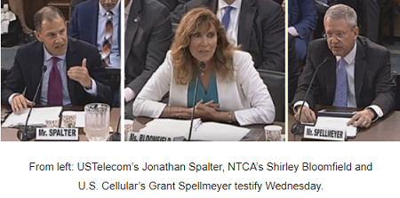
The House Communications and Technology Subcommittee is considering five bills to improve the accuracy of the FCC’s broadband location maps. Bi-partisan lawmakers heard from industry experts on Capitol Hill Wednesday about what they suggest are doable, fast and cost-effective fixes before the maps are used to direct federal subsidies to rural broadband providers.
“The lack of clear data has been a sore spot.
Accurate maps of who does and who doesn’t have access to broadband [are needed] to close the digital divide, said Subcommittee Chair Mike Doyle (D-PA) during the hearing. “We can’t solve the problem if we don’t know the scope of the problem.”
The bills being considered would standardize the data submission process so all providers are submitting the same information the same way. The legislation also includes a challenge process so companies can have a chance to correct inaccuracies before funds are dispersed.
Shirley Bloomfield, CEO of NTCA -The Rural Broadband Association, said the current maps are “frustrating, inconsistent and not reliable.” She noted the FCC last month voted to move away from census block data which assumes if one location in a block has broadband speeds of at least 25mpbs/3mpbs service, the whole block does. She stressed there needs to be a verification process, and crowd-sourcing can be one way of accomplishing that.
Bloomfield called verification, “one last sanity check to enable providers and policymakers” to ensure government funds are not used to over-build in areas that already have broadband connectivity.
James Assey, EVP NCTA – The Internet & Television Association, said the Commission has been working to improve the maps for two years. “The FCC already collects a wealth of data from broadband providers. [We] don’t want to muddy waters, increase costs and delay getting broadband to rural areas.” Assey said the cable industry is focused on developing shape files, in which companies draw a shape that matches their service area and layer that onto a map.
Representing the wireless industry was Grant Spellmeyer, VP, Federal Affairs & Public Policy, U.S. Cellular. He said accurate mapping can be affected by foliage, terrain and equipment, which can all impact a network’s signal propagation. His company spent $2 million and found “abysmal” results when it conducted drive tests as part of verification for Connect America II funding. “We spent the budget and ran out of time,” said Spellmeyer.
He noted the fixed wireless industry will receive about $10 billion in funding and wireless carriers will receive about $4 billion in the next round of CAF grant awards. Those amounts don’t include the cost to deploy 5G, Spellmeyer added.
USTelecom President/CEO Jonathan Spalter described the industry project his association led to improve the maps. It turned over pilot test results to the Commission, Inside Towers reported, and believes the method can be used across the country. “We are working with the FCC to scale our approach nationwide,” said Spalter.
All witnesses agreed the public should be able to see the maps; they cannot now. The maps “need to include who’s providing coverage where,” said Spellmeyer. Perhaps “the height on a tower where someone has a particular antenna someone might want to keep confidential — but most other points are not” sensitive, he said.
Though many other providers contributed to the USTelecom-led mapping pilot, the cable industry did not, said Spalter. “I’m disappointed not all providers joined the effort, particularly the cable industry. We want to work with everyone,” including federal, state and local government agencies on the effort he said.
When asked about that, Assey said cablecos “are focused on delivering shape files to show areas already served.” The cable industry is making progress and believes this is the first step towards better broadband maps, he added.
All witnesses agreed the new maps need to be flexible as technologies change. When asked whether low-earth orbiting satellites can help fill-in broadband coverage gaps, both Spellmeyer and Spalter doubted it. “Speaking for the wireless industry, I’m not certain those low-earth orbiting satellites can deliver a product that can [be sustained] in an automobile moving at 70 mph,” Spellmeyer said.
“5G is not going to be available through technologies like satellite. You need wireline” for backhaul, Spalter added. Comments? Email Us.
The bills being considered are:
- H.R. 2643, the “Broadband Mapping After Public Scrutiny Act of 2019”
- H.R. 3162, the “Broadband Data Improvement Act of 2019”
- H.R. 4128, the “Map Improvement Act of 2019”
- H.R. 4229, the “Broadband Deployment Accuracy and Technological Availability Act”
- H.R. 4227, the “Mapping Accuracy Promotion Services Act”
By Leslie Stimson, Inside Towers Washington Bureau Chief
September 12, 2019


Reader Interactions